| 3.5. Import gravity data from a text dump | ||
|---|---|---|
| Chapter 3. Processing gravity loops | | |
| 3.5. Import gravity data from a text dump | ||
|---|---|---|
| Chapter 3. Processing gravity loops | | |
Blue Whale Processing Geophysical Software can import data in Scintrex CG-3, CG-5, CG-6, or GF Instruments LG-1 txt format. Dump CG-3 data using serial interface or CG-5 data using BlueWhale RS-232 dump utility.
The Scintrex CG-5 file should look like this example:
/	CG-5 SURVEY
/	Survey name:   	test
/	Instrument S/N:	10001
/	Client:        	test
/	Operator:      	tt
/	Date:          	2010/ 1/27
/	Time:          	03:07:03
/	LONG:        	015.1000000 E
/	LAT:         	50.0000000 N
/	ZONE:        	13
/	GMT DIFF.:   	-1.0

/	CG-5 SETUP PARAMETERS
/	Gref:			0.000
/	Gcal1:		9142.072
/	TiltxS:		616.971
/	TiltyS:		642.392
/	TiltxO:		18.041
/	TiltyO:		80.008
/	Tempco:		-0.138
/	Drift:		1.000
/	DriftTime Start:	03:07:04
/	DriftDate Start:	2010/01/27

/	CG-5 OPTIONS
/	Tide Correction:    YES
/	Cont. Tilt:         YES
/	Auto Rejection:     YES
/	Terrain Corr.:       NO
/	Seismic Filter:     YES
/	Raw Data:            NO
Line	   0.000S
/------LINE-----STATION-----ALT.------GRAV.---SD.--TILTX--TILTY-TEMP---TIDE---DUR-REJ-----TIME----DEC.TIME+DATE--TERRAIN---DATE
 0.0000000  5000.0000000   22.5096   3179.602 0.006    1.4   -1.4 -1.91 -0.010  60   0 03:08:58     40173.13102    0.0000  2010/01/27
 0.0000000  5000.0000000   23.2420   3179.594 0.011    0.3   -2.2 -1.92 -0.009  60   0 03:10:15     40173.13191    0.0000  2010/01/27
 0.0000000  5000.0000000   23.7303   3179.592 0.011   -0.9   -3.7 -1.95 -0.009  60   0 03:11:33     40173.13281    0.0000  2010/01/27
The Scintrex CG-3 file should look similar to this:
-------------------------------------------------------------------------------
SCINTREX V5.2       AUTOGRAV / Field Mode            R5.21
                                                             Ser No:    908464.
Line:      0.  Grid:      1.   Job:      1.  Date: 11/04/19  Operator:       1.

GREF.:                       0. mGals           Tilt x sensit.:           260.0
GCAL.1:                6148.776                 Tilt y sensit.:           306.7
GCAL.2:                      0.                 Deg.Latitude:             43.70
TEMPCO.:                 -0.108 mGal/mK         Deg.Longitude:             79.6
Drift const.:         -0.4217727                GMT Difference:            4.hr
Drift Correction Start  Time: 17:00:54          Cal.after x samples:        999
                        Date: 11/04/18          On-Line Tilt Corrected = "*"
-------------------------------------------------------------------------------
Station  Grav.     SD.   Tilt x  Tilt y    Temp.    E.T.C.  Dur  # Rej     Time
   999. 8228.076* 0.044     -5.      6.    0.17    0.015     60     0  18:09:43
   999. 8228.081* 0.052     -6.      5.    0.15    0.013     60     0  18:12:47
   999. 8228.087* 0.045     -6.      6.    0.12    0.010     60     0  18:16:49
The Scintrex CG-6 file should look similar to this:
/		CG-6 Survey
/		Survey Name:	A
/		Instrument Serial Number:	000000020010232
/		Created:	2020-01-23 15:23:55
/
/		CG-6 Calibration
/		Operator:	OperatorName
/		Gcal1 [mGal]:	7985.023000
/		Goff [ADU]:	-8388608.000000
/		Gref [mGal]:	0.0000
/		X Scale [arc-sec/ADU]:	0.030894
/		Y Scale [arc-sec/ADU]:	0.031097
/		X Offset [ADU]:	-228684.678017
/		Y Offset [ADU]:	-219836.919200
/		Temperature Coefficient [mGal/mK]:	-0.127000
/		Temperature Scale [mK/ADU]:	-0.000111
/		Drift Rate [mGal/day]:	0.000000
/		Drift Zero Time:	2020-01-09 13:10:18
/		Firmware Version:	CG6_2_20190125
/
/Station	Date	Time	CorrGrav	Line	StdDev	StdErr	RawGrav	X	Y	SensorTemp	TideCorr	TiltCorr	TempCorr	DriftCorr	MeasurDur	InstrHeight	LatUser	LonUser	ElevUser	LatGPS	LonGPS	ElevGPS	Corrections[drift-temp-na-tide-tilt]
1	2020-01-23	15:23:55	4218.2021	0	0.0235	0.0030	4218.1425	9.1	1.3	0.9139	-0.0572	0.0010	0.1158	0.0000	60	0.000	43.700000	-79.600000	200.00	43.784672	-79.357224	141.2	01011
1	2020-01-23	15:24:55	4218.2043	0	0.0191	0.0025	4218.1447	8.5	0.7	0.9088	-0.0570	0.0008	0.1157	0.0000	60	0.000	43.700000	-79.600000	200.00	43.784634	-79.357300	141.2	01011
1	2020-01-23	15:25:55	4218.2021	0	0.0191	0.0025	4218.1426	9.1	0.8	0.9100	-0.0568	0.0009	0.1154	0.0000	60	0.000	43.700000	-79.600000	200.00	43.784523	-79.357567	127.2	01011
The GF Instruments LG-1 file should look similar to this:
Control unit:	19080003 v1.0.1
Probe:	19110011 v1.0 (LG-1)
Measure:	Continous
Locality:
Note:
Measure time:	60 sec
Coordinates format:	Lat / Long

Point	Date	Time	Ext. Latitude	Ext. Longitude	Ext. Altitude	Ext. Sattelites	Ext. Fix quality	Int. Latitude	Int. Longitude	Int. Altitude	Int. Sattelites	Int. Fix quality	G_nominal	Height	Measurement	St_deviation	Drift&Offset_correction	Height_correction	Tide_correction	G_corrected	Tilt_X	Tilt_Y	Duration	Note
[-]	[-]	[-]	[deg]	[deg]	[m]	[-]	[-]	[deg]	[deg]	[m]	[-]	[-]	[mGal]	[cm]	[mGal]	[mGal]	[mGal]	[mGal]	[mGal]	[mGal]	[deg]	[deg]	[s]	[-]
1	2020-02-11	3:04:24 AM											---	0.0	66.1323	0.0918	0.0000	0.0000	-0.0559	66.0764	0.0017	-0.0027	60
2	2020-02-11	3:05:23 AM											---	0.0	66.1264	0.1176	0.0000	0.0000	-0.0553	66.0711	0.0018	-0.0027	60
3	2020-02-11	3:06:23 AM											---	0.0	66.1238	0.1094	0.0000	0.0000	-0.0547	66.0691	0.0016	-0.0027	60
| Note | |
|---|---|
GF Instruments LG-1 import uses station 0 and line 0 as default values in Continuous or Point measure mode. In the Continuous mode point numbers are completely ignored and default station 0 is assigned to each measurement. |
| Note | |
|---|---|
Exact format of the import files can slightly differ depending on settings of the instrument; nevertheless the software should handle any dumped file correctly. If your file was not imported properly, please report the problem using the Help -> Report bug option from the main menu and copy content of your file which is failing to be imported into the description field. |
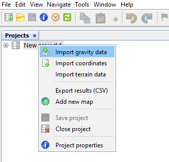
Right-click your project in the Projects window and select the Import gravity data option:
Select file to import in the file selection dialog and click Open. The file is imported into your project as follows:
new loop is created in your project and named after imported file name;
instrument used for the data acquisition is included into Instruments node if not existed yet, the same instrument is set for the new loop;
new reading is created in the loop for each reading line in the imported file;
non-existing lines and stations are created in the project;
last reading from each station occupation is enabled in the newly created loop.
| Note | |
|---|---|
If your data are imported into new project whose coordinates and GMT difference are not set yet, these values are imported from the dump file header. You are informed about it in a warning dialog. |
| | ||
| 3.4. View and save drift plot | 3.6. Batch data updates |