| 4.2. Import stations coordinates | ||
|---|---|---|
| Chapter 4. Work with lines and stations | | |
Software can import coordinates from Comma-separated-values (CSV) file format or text data formatted by Magellan GNSS Solutions software.
Comma-separated values (CSV) format coordinates file has to contain station name, latitude, longitude and elevation data. In addition, line name can be provided.
The CSV file must contain header line with column names. Data are recognized according to the column names as follows:
| Column name | Data values |
| Line | Name of the line (optional); if the line does not exist, new line will be created |
| Station | Name of the station; if the station exists in the given line, coordinates will be overwritten with new values |
| Latitude or Lat | Station latitude in degrees |
| Longitude or Lon | Station longitude in degrees |
| UTMX or Easting | Station UTM easting in meters |
| UTMY or Northing | Station UTM nothing in meters |
| Elevation or Altitude or Alt | Station elevation in meters |
| Terrain or Terrain corr. or Terrain correction | Value of terrain correction in mGal |
| Instrument height | Default instrument height value for the station. If instrument height value for a gravity reading is zero, default value for its station is used. |
| Note | |
|---|---|
Columns in the CSV file can be presented in any order. Unrecognized columns are skipped. Column names are case-sensitive; e.g. data from the column named "Alt" will be imported as stations elevations while column named "alt" will be ignored. |
| Note | |
|---|---|
UTM coordinates, if present, are preferenced over geographic coordinates. |
| Note | |
|---|---|
If Instrument height value is imported for each station with geographic data, any value different from the default value must be manually entered into the Loop table for the corresponding station occupation. |
| Tip | |
|---|---|
Instrument height values used for calculations for the particular station can be easily inspected by expanding the corresponding Station node in the Line table. Similarly, all instrument heights used for a gravity loop can be printed for each station occupation in the Loop report. The Instrument heights checkbox must be selected in the Output and reporting tab of the Project properties window. |
The CSV coordinates file can look like this example:
Station,Longitude,Latitude,X,Y,Elevation,Line
BASE,29.58821399,37.6643881,728300,4171800,1270,0
0,29.59081675,37.66527561,728526.9,4171904.84,1280.59,200
100,29.59042609,37.66444295,728494.99,4171811.48,1272.76,200
120,29.59033712,37.66427703,728487.65,4171792.85,1270.48,200
| Note | |
|---|---|
Columns X and Y will be ignored in the above example. If you rename columns X nd Y to UTMX and UTMY, geographic coordinates will be ignored and UTM coordinates will be converted to latitude and longitude using project datum settings. |
Blue Whale Processing Geophysical Software can import coordinates data from the file prepared from the Stations table in the Magellan GNSS Solutions software provided as an option by the manufacturer with some Ashtech, Thales and Magellan GNSS receivers.
To prepare the file for import, in the Workbook of your adjusted project in the GNSS Solutions software click the Points tab. Select the whole table by a click to the upper-left (blank) cell of the table. Right-click the table and select the "Copy" option. Open a blank text file in Notepad and paste the selected data into it. Save the Notepad txt file at the suitable location in your computer.
The prepared txt file should look like this:
Name	Description	Long	Lat	Ellips height	Status	Constraints	Surv_Horz_Conf	Surv_Height_Conf	Type	Warning
BASE		15° 17' 47.09059"E	50° 08' 09.01157"N	496.662	Adjusted	Horizontal & Vertical Fixed (3D)	0.000	0.000	Control Point	No
2001	 	15° 13' 48.81734"E	50° 07' 42.76530"N	474.735	Adjusted	No constraints	0.022	0.015	Logged Point	No
2002	 	15° 13' 26.49182"E	50° 09' 36.53375"N	413.180	Adjusted	No constraints	0.026	0.018	Logged Point	No
2003	 	15° 16' 21.78458"E	50° 12' 53.36935"N	433.376	Adjusted	No constraints	0.031	0.019	Logged Point	No
| Note | |
|---|---|
Only stations with status "Adjusted" will be imported. Please adjust your network solution before making the import file. |
| Important | |
|---|---|
GNSS Solutions import txt file should contain stations from a single line only. In case your GNSS Solutions project contains stations from more than one line, prepare separate file for each line containing stations from the corresponding line only. |
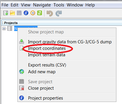
Right-click your project icon in the Projects window and select the "Import coordinates" option:

Select data file prepared in the previous step and click Open. Coordinate data will be imported into appropriate lines/stations of your project.
| Note | |
|---|---|
Please check the "Geodetic reference frame" and "Elevation datum" settings in the Project properties dialog whether correspond to your data. After import, all coordinates are transformed to the BlueWhaleProcessing internal reference, WGS-84 with ellipsoidal elevation datum. This means, that change of datum or reference frame does never influence any existing coordinates in the project. |
| Tip | |
|---|---|
If your coordinates file does not contain "Line" column, right-click the icon of line into which you would like to import data instaed of the project icon. Data will be imported into the proper line. GNSS Solutions file does never contain line information. |